 Pencil, watercolour on paper, 143 x 1123 mm; part 1: 143 x 181 mm; part 2: 143 x 472 mm; part 3: 143 x 466 mm
Map: III
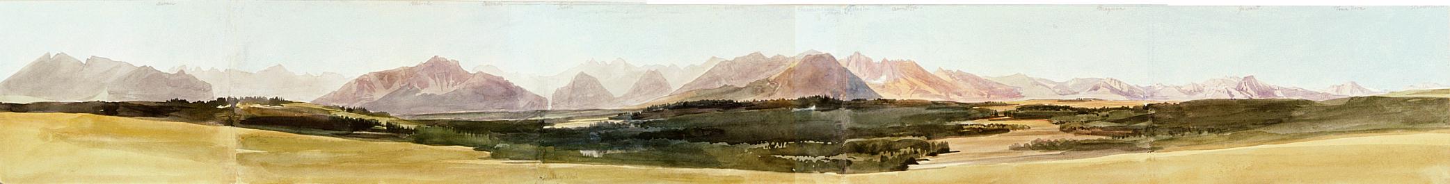
Bukowina (present-day Bukowina Tatrzańska) village was founded in the 17th century. The first mountain guides came from here and the adjacent villages. Following the first dismemberment of Poland in 1772, the village was annexed to the Habsburg Empire; it was reannexed to Poland after World War I. - Owing to our observation post near Bukowina, in the centre of the arc formed by the main ridge of the High Tatras, bending from the Belianske Tatry to the Liptovské Tatry, we can get a panoramic view of the entire Tatras. Reading from the east westwards (i.e., from the left rightwards) the places mentioned by the inscriptions include the Muráň (1890 m) in the western end of the Belianske Tatry and the Široká (2210 m), and in between, in the direction of Javorina, the eastern mass of the High Tatras at the back, with the L'adovy štít (2628 m), its highest peak; "Colbach" most likely refers to Studená dolina, which is found on the other side of the mountain, though not in this direction; Žabia dolina Bielovodská ("Schabbia Thal"?) is seen right of the Široká; Serolo (?); the mass of the Wołoszyn (2155 m), which runs from the east westwards, north of Morskie Oko and the Czarny Staw, between Dolina Roztoki and Dolina Waksmundzka; still farther in the same direction, we see Stawy Ga,sienicowe in front of the Kasprowy Wierch (1985 m); the conical Koszysta (2193 m) in front of the Wołoszyn is surrounded from the west by Dolina Pańszczyca ("Bann Zizza"); Kopa Magury (1704 m) south-east of Zakopane; Giewont (1894 m) south of Zakopane; the Polska Tomanowa (1979 m) on the border (although it should be seen left of Giewont, it is covered by higher peaks here) - the mountain called Polska Tomanowa here should rather be identified with the Kominiarski Wierch (1829 m); and the Czerwony Wierch (1756 m) in the Liptovské Tatry, east of the Volovec (2065 m). - Bibliography: Šimko, Vysoké Tatry 1958. - For information on The High Tatras, see: